- التسوق ، اصبح سهلا.
- /
- احصل على التطبيق!


Bring geography to life with the US & World Laminated Intermediate Classroom Map Pack by BrightWay Educational. Designed for grades 6-12, this detailed set features shaded relief maps of both the United States and the World, with large, easy-to-read fonts and bright colors for clear differentiation of countries, territories, and physical features. With additional details like georeference and degree lines, and national capitals & major cities, and disputed areas, this map set offers a more advanced exploration of geography for middle and high school students. These maps were developed alongside teachers to ensure they are perfect for enhancing classroom learning. These maps are constantly being updated, making the maps the most up-to-date on the market. Map Details: World Map (Eckert IV Projection): An equal-area projection that accurately portrays landmass sizes with minimal distortion. Features detailed insets of Europe, Antarctica, and the Arctic, as well as an inset showing all continents and oceans, providing an even broader view of global geography. United States Map (Albers Equal Area): Depicts the U.S. with accurate proportions for all landmasses, ensuring geographical accuracy. Pick Your Choice of Additional Map Features: Flags: Choose the flags variation to include flags of the countries pictured on the map for added educational value. Educational Panels: Choose the Educational Panels option to include the following panels: o Population Density: Darker colors represent denser population areas, with major cities clearly highlighted. o Elevation & Terrain: An elevation ramp showcases the range of high and low elevations, with major physical features depicted in shaded relief and a side-on elevation profile for additional context. Ideal for use in classrooms, homeschooling environments, and educational spaces, the Laminated Intermediate Classroom Map Pack by BrightWay Educational is an essential tool for students in grades 6-12 to explore and gain a deeper understanding of the world. With enhanced details such as shaded relief, disputed areas, and major physical features, this map set provides a comprehensive learning experience that encourages critical thinking and global awareness. Perfect for fostering an advanced level of geographic knowledge, it's designed to inspire curiosity and in-depth exploration of both political and physical geography.
 -13%
شرائط القراءة الموجهة ، 32 جهاز كمبيوتر أبرز شرائط ملونة تراكب جملة تسليط الضوء على قطاع القارئ تعقب الإشارة المرجعية عُسر القراءة أدوات القراءة للطلاب مساعد إمدادات المعلم
KWD 3.500
-13%
شرائط القراءة الموجهة ، 32 جهاز كمبيوتر أبرز شرائط ملونة تراكب جملة تسليط الضوء على قطاع القارئ تعقب الإشارة المرجعية عُسر القراءة أدوات القراءة للطلاب مساعد إمدادات المعلم
KWD 3.500
 هدايا عاشق الكتب للنساء القراء الكتب الكتب المضحكة الملحقات لمحبي القراءة نادي الكتب هدية الكتب عناصر فريدة من نوعها هدية تقدير المكتبة المدرسية التي تصرفها بسهولة من قبل الكتب ذات الطابع الرئيسي
KWD 3
هدايا عاشق الكتب للنساء القراء الكتب الكتب المضحكة الملحقات لمحبي القراءة نادي الكتب هدية الكتب عناصر فريدة من نوعها هدية تقدير المكتبة المدرسية التي تصرفها بسهولة من قبل الكتب ذات الطابع الرئيسي
KWD 3
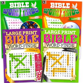 البحث عن كلمة الكتاب المقدس 4 حزمة للمراهقين ، البالغين - حزمة مع 4 متنوعة من عمليات البحث عن كلمة الكتاب المقدس كبيرة المطبوعة بالإضافة إلى القلم | كتب البحث عن الكلمات للكبار وكبار السن (300+ الألغاز)
KWD 6.500
البحث عن كلمة الكتاب المقدس 4 حزمة للمراهقين ، البالغين - حزمة مع 4 متنوعة من عمليات البحث عن كلمة الكتاب المقدس كبيرة المطبوعة بالإضافة إلى القلم | كتب البحث عن الكلمات للكبار وكبار السن (300+ الألغاز)
KWD 6.500
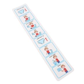 Brrnoo Potty Training الجدول الزمني البصري ، الجدول الزمني لقعادة التوحد خطوة بخطوة خطوة بخطوة الجداول البصرية للأطفال مغلفة القعادة الجدول الزمني المرحاض ASD المرئي للأطفال ، #311
KWD 3.500
Brrnoo Potty Training الجدول الزمني البصري ، الجدول الزمني لقعادة التوحد خطوة بخطوة خطوة بخطوة الجداول البصرية للأطفال مغلفة القعادة الجدول الزمني المرحاض ASD المرئي للأطفال ، #311
KWD 3.500


