- Shopping, made easy.
- /
- Get the app!

Unique, color banded, this political LARGE PRINT map of Tennessee state features geographic detail and accuracy. The map shows all county boundaries, county names with their capitals. Perfect for Schools, Home, Office or Home Schooling. - Large Print for easy reading - Counties with banded boundaries - All counties and their capitals - Selection of cities, parks, monuments, major Roads, and major Geographical features
 Happy Start Tummy Time Books for Babies – High Contrast Baby Book, Black and White Books for Newborns, Hospital Approved Baby Board Books, Stand Up High Contrast Books for Newborns Ages 0+ Portuguese
KWD 4
Happy Start Tummy Time Books for Babies – High Contrast Baby Book, Black and White Books for Newborns, Hospital Approved Baby Board Books, Stand Up High Contrast Books for Newborns Ages 0+ Portuguese
KWD 4
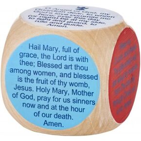 Autom Catholic Children's Prayer Cube
KWD 7
Autom Catholic Children's Prayer Cube
KWD 7
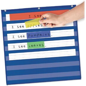 EAMAY Sentence Strips Highlighter for Pocket Chart, Guided Reading Strips, Reading Tracker, School Classroom Teacher Supplies, 4 Assorted Colors, 24" x 3", 12 Strips
KWD 5.500
EAMAY Sentence Strips Highlighter for Pocket Chart, Guided Reading Strips, Reading Tracker, School Classroom Teacher Supplies, 4 Assorted Colors, 24" x 3", 12 Strips
KWD 5.500
 PATIKIL 22 Pcs Dyslexia Reading Tools, 2 Sizes Reading Tracker Guided Reading Strips with Transparent Strip Colored Overlay Highlight Bookmarks for Teacher, Blue
KWD 5
PATIKIL 22 Pcs Dyslexia Reading Tools, 2 Sizes Reading Tracker Guided Reading Strips with Transparent Strip Colored Overlay Highlight Bookmarks for Teacher, Blue
KWD 5