- التسوق ، اصبح سهلا.
- /
- احصل على التطبيق!
Martha's Vineyard, MA NOAA 13233. This Framed Nautical Map covers the waters and coast line of Martha's Vineyard, MA. The Framed Nautical Chart is the official NOAA Nautical Chart detailing the beautiful waters surrounding Martha's Vineyard Island; including Nashawena Island, Pasque Island, Naushon Island, Nonameset Island, Buzzards Bay, Vineyard Sound and other towns and harbors. NOAA Nautical Chart 13233. Standard frame is approx 20" H x 24" W. Poster frame is 31" H x 36" W. Solid Hardwood Frame, Glass Front, Black Mat, Paper Duster Backing with Wire Hanging, Handmade in USA
 منصات الحيض القابلة لإعادة الاستخدام. 100% قطن (بنفسجي بالضباب)
KWD 5
منصات الحيض القابلة لإعادة الاستخدام. 100% قطن (بنفسجي بالضباب)
KWD 5
 فستان عباية شيفون جلابية مطرز من بولي جولي للنساء ملابس العيد الإسلامية في دبي سادوي مع غطاء للرأس
KWD 27
فستان عباية شيفون جلابية مطرز من بولي جولي للنساء ملابس العيد الإسلامية في دبي سادوي مع غطاء للرأس
KWD 27
 -36%
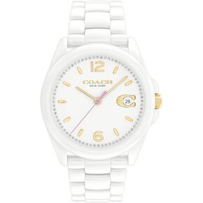
ساعة كوتش جريسون النسائية | مقاومة للماء | حركة الكوارتز | الارتقاء بالأناقة لكل مناسبة (موديل 14503926)
KWD 71
-36%
ساعة كوتش جريسون النسائية | مقاومة للماء | حركة الكوارتز | الارتقاء بالأناقة لكل مناسبة (موديل 14503926)
KWD 71
 -30%
المدرب سوينغ الرمز البريدي، الطباشير
KWD 104.500
-30%
المدرب سوينغ الرمز البريدي، الطباشير
KWD 104.500


