- Shopping, made easy.
- /
- Get the app!
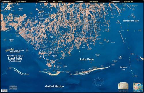
Standard Laminated Map Last Isle/Cocodrie SM019 This satellite aerial photo map is the perfect tool for the fisherman or outdoor enthusiast. The high resolution satellite photo map allows the inshore fisherman to see more accurate detail and hidden spots than that of a traditional navigation chart. Backwater areas come alive in this map. Get to places most people don't know about!
 Map Ruler for Measuring LAT/Lon, Miles, and Kilometers at a Single map Scale
KWD 3
Map Ruler for Measuring LAT/Lon, Miles, and Kilometers at a Single map Scale
KWD 3
 YellowMaps Merchants Millpond NC topo map, 1:24000 Scale, 7.5 X 7.5 Minute, Historical, 1981, Updated 1981, 26.9 x 21.9 in
KWD 12.500
YellowMaps Merchants Millpond NC topo map, 1:24000 Scale, 7.5 X 7.5 Minute, Historical, 1981, Updated 1981, 26.9 x 21.9 in
KWD 12.500
 Adventure Set of 4 Map Rulers 1:24,000 1:62,500 1:100,000 1:126,720
KWD 6
Adventure Set of 4 Map Rulers 1:24,000 1:62,500 1:100,000 1:126,720
KWD 6
 Garmin Delorme Atlas & Gazetteer Paper Maps- NH/VT, AA-008826-000
KWD 16.500
Garmin Delorme Atlas & Gazetteer Paper Maps- NH/VT, AA-008826-000
KWD 16.500