E1 RTK GNSS Survey Equipment GPS Receiver with IMU Rover & Base Handheld Collector Land Total Station Surveying Equipment, Navigation System Survey Software(include Pole, Tribrach, Tripod)
All electronics ship with US style plugs.You may need a voltage converter or a plug adapter.
Special Features
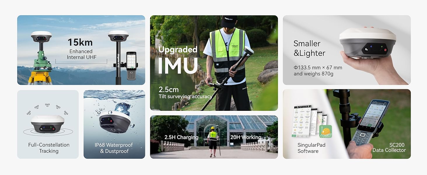
【5KM (3.11 miles) Radio】E1 GNSS Surveying System supports up to 5KM range in base-rover mode, unaffected by network or environment. Can also connect to CORS/NTRIP for centimeter-level accuracy.
【60°Tilt Surveying】E1 GNSS survey equipment with IMU, can initializes in 5 seconds and supports tilt measurements up to 60°, and compatible with regular 5/8" thread poles.
【20 Hours Endurance 】E1 RTK GNSS provides 6700mah over 20 hours of continuous operation on a single charge, with fast Type-C charging. It employs a base station and rover with the (GPS) to attain Centimeter-Level Precision Measurement, High precision with low power consumption, small size easy to carry and operate.
【Various Interfaces】E1 gnss rtk innovative integration of multiple connection methods: NFC (Touch connection) /Bluetooth/USB Type-C/WiFi/TNC Connector/RS232 Serial Port. Easily access static data download, Configuration, device Status check, and Firmware Upgrade.Improve your work efficiency by 30%!!
【Robust Signal Tracking】E1 GNSS RTK support Full-Constellation Tracking: GPS/GLONASS/Galileo/BDS/QZSS/IRNSS/SBAS etc, an easily obtain fixed RTK solution in seconds even in challenging environments like multipath, trees, and city canyons.
【1-On-1 Support Service】Our rtk gps enjoy a one-year warranty and lifetime technical support for a hassle-free experience. Complete user manual and video tutorials to help you get started at ease. Both field Surveying Software SingularPad and Post-processing Software are included. Software installed in Collector are Permanently Valid, We provide permanent free software upgrade and update services.
【ABOUT US】SingularXYZ focuses on high precision GNSS PNT (Positioning, Navigation & Timing) technology, extending its coverage to geospatial information, precision agriculture, machine control, robotics, telecom, IoT and etc., providing reliable, stable and professional products and service, committed to popularizing precision and intelligence into all aspects of people's lives, contributing to the construction of an informatized, intelligent and efficient world.
【Support】Buyers can always contact the seller's tech team to ensure the gnss survey equipment works perfectly. Please refer to the manual included in the package, email us for technical support, or visit the SingularXYZ website to get in touch. We also offer video conference guidance to assist you.
Note: U.S. users must apply for an FCC radio license for commercial use (e.g., surveying, construction) with the UHF function (450–470 MHz). The device is FCC certified, and we can provide supporting info if needed.

 Dash Cam Charger Cable, GPS Navigator Charger Cable for Mini USB Port, Dash Cam Charge Cable, Left Port Dash Charging Cable for 12V Car and 24V Truck Power Adapter Cable (Left-90 Degree)
KWD 6
Dash Cam Charger Cable, GPS Navigator Charger Cable for Mini USB Port, Dash Cam Charge Cable, Left Port Dash Charging Cable for 12V Car and 24V Truck Power Adapter Cable (Left-90 Degree)
KWD 6
 Universal Phone Adhesive Adapter Compatible with Garmin Edge Bicycle Mount (Black-2pcs)
KWD 3.500
Universal Phone Adhesive Adapter Compatible with Garmin Edge Bicycle Mount (Black-2pcs)
KWD 3.500
 Approach G8 Charger,USB Charger Cord Compatible for Bushnell Neo Ghost Bushnell Phantom,Garmin Approach G30 G8 G80 Z80 Z82,Izzo Swami 6000,Foretrex 601,GolfBuddy Voice 2 Voicex VT3 VS4 Golf GPS
KWD 3
Approach G8 Charger,USB Charger Cord Compatible for Bushnell Neo Ghost Bushnell Phantom,Garmin Approach G30 G8 G80 Z80 Z82,Izzo Swami 6000,Foretrex 601,GolfBuddy Voice 2 Voicex VT3 VS4 Golf GPS
KWD 3
 ChargerCity Heavy Duty Large 22mm Suction Mount for Garmin Overlander dezl OTR1000 OTR1010 OTR800 OTR810 RV 1090 1095 890 895 DriveSmart 86 8"-10" Truck GPS Navigator
KWD 9
ChargerCity Heavy Duty Large 22mm Suction Mount for Garmin Overlander dezl OTR1000 OTR1010 OTR800 OTR810 RV 1090 1095 890 895 DriveSmart 86 8"-10" Truck GPS Navigator
KWD 9


