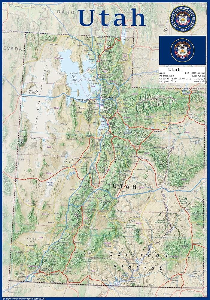
ولاية يوتا هي ولاية غير ساحلية في منطقة الجبل الغربية في غرب الولايات المتحدة. يحد كولورادو إلى شرقها ، وايومنغ إلى شمال شرقها ، وأيداهو إلى شمالها ، وأريزونا إلى الجنوب ، ونيفادا إلى غربها. يوتا يمس أيضًا زاوية من نيو مكسيكو في الجنوب الشرقي.
تعرض هذه الخريطة المادية في ولاية يوتا معلومات رئيسية مثل مدن العاصمة والسكان وحجم المنطقة وأكبر مدينة ، بالإضافة إلى مواقع المطارات والطرق السريعة الرئيسية وحدود الولاية والمناطق المأهولة بالسكان. بالإضافة إلى ذلك ، تشمل الخريطة مسطحات المياه ونقاط الاهتمام مثل الحدائق الوطنية والولائية والغابات والمواقع الثقافية والمزيد.
 ملصق للحديقة الوطنية الأمريكية لعشاق الطبيعة والأماكن الخارجية - حجم كبير 23 بوصة × 17 بوصة - رسوم توضيحية كبيرة جدًا لجميع المتنزهات الوطنية البالغ عددها 63 - - قائمة دلو لرحلات الطريق
KWD 9.500
ملصق للحديقة الوطنية الأمريكية لعشاق الطبيعة والأماكن الخارجية - حجم كبير 23 بوصة × 17 بوصة - رسوم توضيحية كبيرة جدًا لجميع المتنزهات الوطنية البالغ عددها 63 - - قائمة دلو لرحلات الطريق
KWD 9.500
 خريطة ملصق ولاية أوريغون - 23.3 × 16.5 بوصة - مغلفة بالورق
KWD 10.500
خريطة ملصق ولاية أوريغون - 23.3 × 16.5 بوصة - مغلفة بالورق
KWD 10.500
 شرائط الجوائز، شريط روزيت، ميداليات الجوائز، الفائز بشريط الجائزة، شرائط النصر، المركز الأول والثاني والثالث لجوائز الفصل الدراسي، شرائط تقدير الشرف، حدث رياضي، أزرق أحمر أبيض (3 قطع)
KWD 4
شرائط الجوائز، شريط روزيت، ميداليات الجوائز، الفائز بشريط الجائزة، شرائط النصر، المركز الأول والثاني والثالث لجوائز الفصل الدراسي، شرائط تقدير الشرف، حدث رياضي، أزرق أحمر أبيض (3 قطع)
KWD 4
 -24%
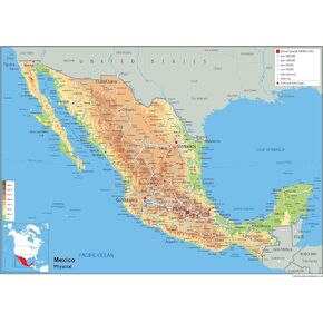
خريطة الملصقات المادية للمكسيك - 16.53 × 23.38 بوصة - ورق مغلف
KWD 8
-24%
خريطة الملصقات المادية للمكسيك - 16.53 × 23.38 بوصة - ورق مغلف
KWD 8