FOR THE EXPLORER: Plan your trip to the Yosemite Valley, the Coastal Redwoods, or find the spot of your favorite recreation areas nearby
ACCURATE DATA: Road conditions and recreation potential are verified by field-checkers exploring the American West and beyond
TRUSTED PUBLISHER: Our award-winning team of cartographers and editors work tirelessly to present the landscapes and data that travelers must have in order to maximize their experience
HIGH QUALITY PRINT: Printed on thick paper suitable as a poster for display on your home, school or office wall.
ROLLED IN A STURDY TUBE: Your map is rolled and packaged in a sturdy tube to protect it during shipment
وصف
Few places in the world can claim such diverse landscapes and seascapes as California. This map illustrates The Golden State's network of highways that grant road travelers access to iconic natural features like Death Valley, Lake Tahoe, Yosemite Valley, and the Coastal Redwoods to name a few.
Printed on thick paper suitable for display on your home, school or office wall. Your map is rolled and packaged in a sturdy tube to protect it during shipment.
 خريطة حائط كولورادو الترفيهية - 26 × 33 بوصة - تصفيح أمامي
KWD 18.500
خريطة حائط كولورادو الترفيهية - 26 × 33 بوصة - تصفيح أمامي
KWD 18.500
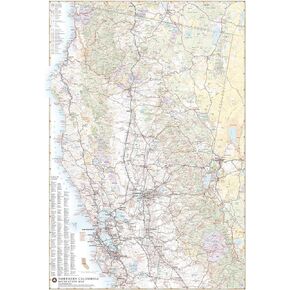 خريطة حائط ترفيهية لشمال كاليفورنيا - 26 × 37 بوصة - تصفيح أمامي
KWD 15.500
خريطة حائط ترفيهية لشمال كاليفورنيا - 26 × 37 بوصة - تصفيح أمامي
KWD 15.500
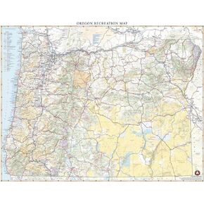 الخرائط المعيارية: خريطة حائط أوريغون الترفيهية - 26 × 33 بوصة - تصفيح أمامي
KWD 18.500
الخرائط المعيارية: خريطة حائط أوريغون الترفيهية - 26 × 33 بوصة - تصفيح أمامي
KWD 18.500
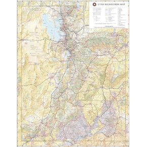 الخرائط المعيارية: خريطة حائط يوتا الترفيهية - 26 × 33 بوصة
KWD 18
الخرائط المعيارية: خريطة حائط يوتا الترفيهية - 26 × 33 بوصة
KWD 18

