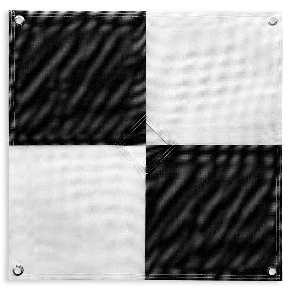
48”x48” AERIAL TARGETS - Designed for low to medium altitude drone mapping and scanning, these drone GCPs were made for drone mapping up to 400 feet. The standard size is useful when scaling and verifying the map, providing a standard reference distance during post-processing.
DRONE GCP WITH CENTER PASSTHROUGH - The center passthrough design allows pre-established survey stakes or survey markers to be slid directly through the GCP for added convenience when mapping. Using the passthrough, a surveyor can place markers days or weeks prior to the flight mission. The GCP can then be placed over the existing markers with precision as the surveying marker remains in place during the placement and retrieval of the aerial targets.
LIGHTWEIGHT & DURABLE AERIAL TARGETS - Using a weatherproof mesh material, these GCPs were made to be highly visible yet lightweight, a big benefit when traveling or placing the GCPs in the field. The material is made with a matte finish which reduces glare from sunlight and overexposure on sunny days, which makes selecting the center of the target easier during post-processing.
GCP WITH SOFTWARE COMPATIBILITY - These GCPs are compatible with many popular photogrammetry reconstruction software from the leading companies in the space drone mapping, photogrammetry, and surveying space,. The GCPs are compatible with most auto-detection software, and these GCPs have been used in a wide range of industries and educational training programs with great success.
UAV GCP WITH CORNER ANCHOR POINTS - With eyelets at each corner to easily anchor the aerial targets, the corner anchor points prevent the GCPs from moving during mapping. The anchors also allow the GCPs to be left in the field if needed for repeat flights over a period of time, providing peace of mind that the GCPs offer repeatable location data for high-accuracy mapping and photogrammetry.
وصف
Finally a Ground Control Point (GCP) to meet any UAV Pilot's needs. Great for preexisting survey markers, you can easily overly this target over an existing marker, allowing the pole to pass through the center. With a durable mesh design, this GCP can be reused countless times. Never dread carrying a large GCP around with you again. These lightweight, foldable GCPs are easy to transport and carry. If the wind is a concern, simply use the 4 corner eyelets to anchor the GCP to the ground to ensure that the GCP stays in place. With this iteration of our GCPs. The GCPs can also be used as a scale during the reconstruction process of the aerial mapping due to their exact size. Take your drone mapping to new heights today with the Sky High Bull's-Eye GCP 6 Pack!

 -21%
روكو طائرة درون F11 برو رباعية المراوح بدقة 4K UHD وفيديو مباشر ونظام تحديد المواقع وكاميرا للبالغين والمبتدئين ووقت طيران 30 دقيقة وبطارية 2500mAh ومحرك عديم المسفرات، اسود (بطارية اضافية + شنطة حمل)
KWD 115.500
-21%
روكو طائرة درون F11 برو رباعية المراوح بدقة 4K UHD وفيديو مباشر ونظام تحديد المواقع وكاميرا للبالغين والمبتدئين ووقت طيران 30 دقيقة وبطارية 2500mAh ومحرك عديم المسفرات، اسود (بطارية اضافية + شنطة حمل)
KWD 115.500
 غطاء حماية من السيليكون BRDRC Air 3 لملحقات وحدة التحكم عن بعد DJI Mini 4 Pro Air 3 RC 2 (رمادي)
KWD 7
غطاء حماية من السيليكون BRDRC Air 3 لملحقات وحدة التحكم عن بعد DJI Mini 4 Pro Air 3 RC 2 (رمادي)
KWD 7
 -9%
طائرة بدون طيار صغيرة من تشيروينج CW10 للأطفال واي فاي FPV مع كاميرا، لعبة هدية بدون طيار RC للأولاد والبنات مع تحوم تلقائي، تحكم صوتي
KWD 15
-9%
طائرة بدون طيار صغيرة من تشيروينج CW10 للأطفال واي فاي FPV مع كاميرا، لعبة هدية بدون طيار RC للأولاد والبنات مع تحوم تلقائي، تحكم صوتي
KWD 15
 -12%
DJI موزع شحن ثنائي الاتجاه ميني 3 برو
KWD 22.500
-12%
DJI موزع شحن ثنائي الاتجاه ميني 3 برو
KWD 22.500