Map Size: 14 inches x 2 feet (35.56cm x 60.96cm)| Ready to frame in standard size frame (14x24) |Frame not included
A very attractive example of the 1860 U.S. Coast Survey triangulation chart or map of southern Florida and the Florida Keys. Covers from Key Biscayne Bay south along the Keys, past Key West, as far as the Marquesas Keys. Countless triangulation points are noted throughout. Names each of the Keys and identifies Miami at the northern edge of Key Biscayne Bay, and the city of Key West, at the time a prosperous center of commerce. The chart was produced in, 1860 under the supervision of A.
D. Bache, one of the most influential and prolific Superintendents of the U.S. Coast Survey.
Each map is hand printed in our studio | Quality & Satisfaction Guaranteed | Made in the USA
This giclée print is produced on thick Fine Art Semi Matte Paper (Weight: 235 g/m2, Thickness: 10 mil, ISO brightness: 95%) and coated with a satin finish that maintains vivid colors and faithfulness to the original map. Your giclée print is Archival Quality and guaranteed not to fade for 200+ years.
وصف
A very attractive example of the 1860 U.S. Coast Survey triangulation chart or map of southern Florida and the Florida Keys. Covers from Key Biscayne Bay south along the Keys, past Key West, as far as the Marquesas Keys. Countless triangulation points are noted throughout. Names each of the Keys and identifies Miami at the northern edge of Key Biscayne Bay, and the city of Key West, at the time a prosperous center of commerce. The chart was produced in, 1860 under the supervision of A. D. Bache, one of the most influential and prolific Superintendents of the U.S. Coast Survey.
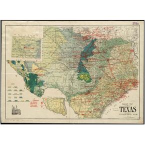 1917 خريطة تكساس النفطية والخريطة الجيولوجية | يظهر حقول النفط وحقول الغاز وخطوط الأنابيب | جاهز للتأطير | الحجم: 18x24 بوصة
KWD 14.500
1917 خريطة تكساس النفطية والخريطة الجيولوجية | يظهر حقول النفط وحقول الغاز وخطوط الأنابيب | جاهز للتأطير | الحجم: 18x24 بوصة
KWD 14.500
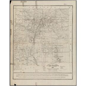 خريطة نيو مكسيكو لعام 1890، مسؤول نيو مكسيكو يُظهر المستوطنات والبلدات ومنح الأراضي والمحمية الهندية|استنساخ الفنون الجميلة العتيقة|جاهز للتأطير
KWD 14.500
خريطة نيو مكسيكو لعام 1890، مسؤول نيو مكسيكو يُظهر المستوطنات والبلدات ومنح الأراضي والمحمية الهندية|استنساخ الفنون الجميلة العتيقة|جاهز للتأطير
KWD 14.500
 تمريرات 10pcs قاعة الفصول الدراسية تمريرات الحمام لفصول الفصل الدراسي تمريرات الفصول الدراسية مع حبل الحبل للجنسين تمريرة مناسبة للمكتب والمطعم ومحطة الوقود
KWD 4
تمريرات 10pcs قاعة الفصول الدراسية تمريرات الحمام لفصول الفصل الدراسي تمريرات الفصول الدراسية مع حبل الحبل للجنسين تمريرة مناسبة للمكتب والمطعم ومحطة الوقود
KWD 4
 -8%
Bazic Primary School Kit Supply Box 57 Count for Ristergarten Elementary Student K-6 ، قلم تلوين كتاب تكوين ، قد يختلف اللون ، حزمة واحدة
KWD 16.500
-8%
Bazic Primary School Kit Supply Box 57 Count for Ristergarten Elementary Student K-6 ، قلم تلوين كتاب تكوين ، قد يختلف اللون ، حزمة واحدة
KWD 16.500

