This up to date map of the Dallas and Fort Worth regional area features up-to-date major roads, cities, highways, zip code boundaries, lakes, hospitals, high schools and more.
Every street is shown, with all major roads labeled (including all Farm-to-Market designations). Freeways (with exit numbers), toll roads, passenger and freight rail lines + stations, airports, marinas, hospitals, colleges, parks, high schools, military installations, major points of interest, rivers, major terrain features, and current zip codes are all included.
Map coverage area: West to include Willow Park and Decatur, North include Denton, Prosper and Melissa, East to include Royse City and Kaufman and South to include Midlothian and Joshua
Laminated which makes it perfect for dry-erase markers
42"H x 54" W
وصف
Area of coverage includes: West to include Willow Park and Decatur, North to include Denton, Prosper and Melissa, East - to include Royse City and Kaufman and South to include Midlothian and Joshua.
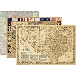 تاريخ تكساس - حزمة من 3 خرائط للفصول الدراسية - تتضمن خريطة ثورة تكساس (1836)، وخريطة تكساس والكومانش (منتصف القرن التاسع عشر)، وخريطة مسارات الماشية العظيمة في تكساس (1876) - 3 خرائط مغلفة بحجم الملصق
KWD 41
تاريخ تكساس - حزمة من 3 خرائط للفصول الدراسية - تتضمن خريطة ثورة تكساس (1836)، وخريطة تكساس والكومانش (منتصف القرن التاسع عشر)، وخريطة مسارات الماشية العظيمة في تكساس (1876) - 3 خرائط مغلفة بحجم الملصق
KWD 41
 خريطة حائط تكساس التنفيذية - مغلفة 42 عرض × 39 ارتفاع
KWD 24
خريطة حائط تكساس التنفيذية - مغلفة 42 عرض × 39 ارتفاع
KWD 24
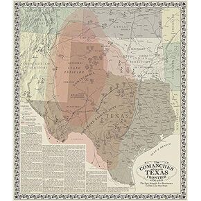 الكومانش وتكساس
KWD 18.500
الكومانش وتكساس
KWD 18.500
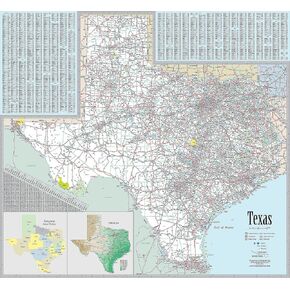 خريطة حائط تنفيذية لتكساس - ورق مقاس 42 عرضًا × 39 ارتفاعًا
KWD 16.500
خريطة حائط تنفيذية لتكساس - ورق مقاس 42 عرضًا × 39 ارتفاعًا
KWD 16.500


