- Shopping, made easy.
- /
- Get the app!
DJI's First Long-Range, High-Accuracy Aerial LiDAR SystemDJI's next-generation high-accuracy aerial LiDAR system features a long-range LiDAR capable of reaching up to 950 m even on objects with just 10% reflectivity. Dual 100MP RGB mapping cameras and a high-precision POS system accelerate geospatial data acquisition, enabling daily coverage of up to 100 sq. km.Less ThanBrGreater ThanLess ThanBGreater ThanHardware Performance RedefinedLess Than/BGreater ThanZenmuse L3 integrates a 1535nm long-range LiDAR, dual 100MP RGB mapping cameras, a high-precision POS system, and a three-axis gimbal, all within a compact device, delivering unprecedented performance for its size.Less ThanBrGreater ThanLess ThanBGreater Than1535nm Long-Range LiDARLess Than/BGreater ThanLess ThanBrGreater ThanLess ThanBGreater ThanLong Range, Wide CoverageLess Than/BGreater ThanZenmuse L3 achieves a maximum detection range of 950 m at a pulse rate of 100 kHz, tested under 100 klx ambient light and on objects with 10% reflectivity. The adjustable pulse rate allows for flexible power output and optimal adaptation to different operational scenarios. Typical flight altitudes of 300 to 500 m significantly expand single-flight coverage and boost mapping efficiency.Less ThanBrGreater ThanLess ThanBGreater ThanSmall Spot, High EnergyLess Than/BGreater ThanWith a laser beam divergence of just 0.25 mrad (1/e), the spot size at the same range is about one-fifth that of Zenmuse L2, enabling detection of smaller objec
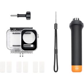 DJI Osmo Action Diving Accessory Kit, Compatibility: Osmo Action 3, Osmo Action 4
KWD 41
DJI Osmo Action Diving Accessory Kit, Compatibility: Osmo Action 3, Osmo Action 4
KWD 41
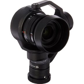 DJI Zenmuse X5S Camera for DJI Inspire 2
KWD 448
DJI Zenmuse X5S Camera for DJI Inspire 2
KWD 448
 DJI Osmo Action 4 Adventure Combo - 4K Waterproof Action Camera with Battery Case Bundle with Lexar 64GB Memory Card, Protective Case, Carrying Case and 1 YR CPS Enhanced Protection Pack
KWD 158.500
DJI Osmo Action 4 Adventure Combo - 4K Waterproof Action Camera with Battery Case Bundle with Lexar 64GB Memory Card, Protective Case, Carrying Case and 1 YR CPS Enhanced Protection Pack
KWD 158.500
 -5%
DJI Osmo Pocket 3 Handheld Gimbal Stabilizer with 1′′ CMOS & 4K/120fps Video, 3-Axis Stabilization Bundle with 10" Hard EVA Case, 64GB Memory Card and 2 YR CPS Enhanced Protection Pack
KWD 301.500
-5%
DJI Osmo Pocket 3 Handheld Gimbal Stabilizer with 1′′ CMOS & 4K/120fps Video, 3-Axis Stabilization Bundle with 10" Hard EVA Case, 64GB Memory Card and 2 YR CPS Enhanced Protection Pack
KWD 301.500


