- التسوق ، اصبح سهلا.
- /
- احصل على التطبيق!

This updated commercial wall map of Florida, produced by the Florida Dept of Transportation, is ideal for anyone needing a comprehensive representation of the state for planning, routing, or reference. It's a great choice for business and sales strategy, urban development, social work outreach, education, and marketing. The Laminated wall map is printed with UV-resistant ink to help prevent color fading. Map details include state highways, federal highways, county highways, county boundaries, cities and towns, major waterways, state/national parks, campsites, rest areas, military installations, airports, golf courses, universities, and much more. You'll also find a city/county index on the map to include inset maps with more detail of major cities!!
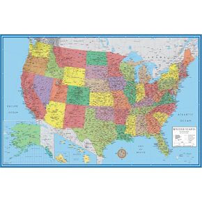 ملصق جداري لخريطة الحائط الكلاسيكية للنخبة مقاس 24x36 بالولايات المتحدة الأمريكية (مصفح)
KWD 3.500
ملصق جداري لخريطة الحائط الكلاسيكية للنخبة مقاس 24x36 بالولايات المتحدة الأمريكية (مصفح)
KWD 3.500
 ملصق جداري لخريطة الحائط التنفيذية للولايات المتحدة الأمريكية مقاس 24 × 36 بوصة (24 × 36 مصفح)
KWD 6.500
ملصق جداري لخريطة الحائط التنفيذية للولايات المتحدة الأمريكية مقاس 24 × 36 بوصة (24 × 36 مصفح)
KWD 6.500
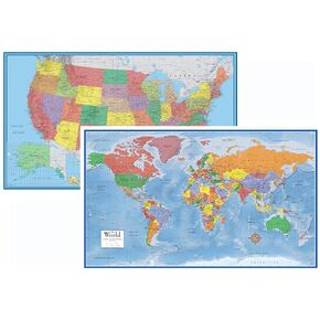 مجموعة خرائط جدارين كلاسيكية ثلاثية الأبعاد للعالم والولايات المتحدة الأمريكية مقاس 24 × 36 (ورقة مطوية)
KWD 10.500
مجموعة خرائط جدارين كلاسيكية ثلاثية الأبعاد للعالم والولايات المتحدة الأمريكية مقاس 24 × 36 (ورقة مطوية)
KWD 10.500
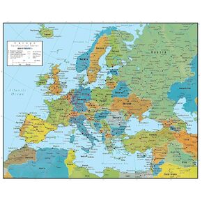 خريطة حائط أوروبا - الطبعة الجيوسياسية من Swiftmaps (18x22 مغلفة)
KWD 7
خريطة حائط أوروبا - الطبعة الجيوسياسية من Swiftmaps (18x22 مغلفة)
KWD 7