- التسوق ، اصبح سهلا.
- /
- احصل على التطبيق!
Celebrate Utah's striking landscapes with this 1988 3D Raised Relief Map, which transforms historical cartography into a tactile, sculpted form. Featuring mountains, valleys, and canyon regions, the relief surface provides an engaging way to experience Utah's topography. Each map is crafted using a detailed process that blends historical scans with elevation data, then shaped through printing, heating, and vacuum-forming. Subtle differences in fine print and text are expected, giving every map unique authenticity. Durable and visually stunning, this raised relief map reflects Muir Way's dedication to creating meaningful works that honor the places we value most.
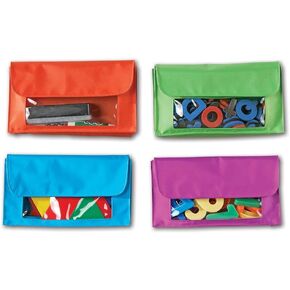 جيوب تخزين مغناطيسية من Learning Resources، مجموعة من 4 في 4 ألوان، حقيبة ملحقات السبورة البيضاء، تنظيم الفصل الدراسي، مستلزمات العودة إلى المدرسة، مستلزمات المعلمين
KWD 11
جيوب تخزين مغناطيسية من Learning Resources، مجموعة من 4 في 4 ألوان، حقيبة ملحقات السبورة البيضاء، تنظيم الفصل الدراسي، مستلزمات العودة إلى المدرسة، مستلزمات المعلمين
KWD 11
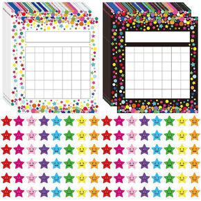 80 قطعة من مخطط الحوافز لمنزل الفصل الدراسي مع 800 ملصق نجمة
KWD 4
80 قطعة من مخطط الحوافز لمنزل الفصل الدراسي مع 800 ملصق نجمة
KWD 4
 مجموعة مكونة من حروف مكونة من 4 قطع من مجموعة Teacher Created Resources Brights 4Ever Bold Block مقاس 4 بوصات
KWD 5.500
مجموعة مكونة من حروف مكونة من 4 قطع من مجموعة Teacher Created Resources Brights 4Ever Bold Block مقاس 4 بوصات
KWD 5.500
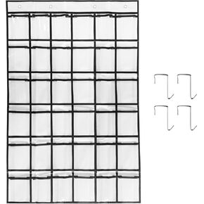 مخطط جيب للفصل الدراسي مكون من 36 جيبًا للهواتف المحمولة، مخطط جيب لحامل الآلة الحاسبة مع ملصق رقم 36 (أبيض)
KWD 4.500
مخطط جيب للفصل الدراسي مكون من 36 جيبًا للهواتف المحمولة، مخطط جيب لحامل الآلة الحاسبة مع ملصق رقم 36 (أبيض)
KWD 4.500


