- التسوق ، اصبح سهلا.
- /
- احصل على التطبيق!
Laminated wall map of the Greater Detroit Metro area showing locations within 30 - 40 miles of downtown Detroit, including all of Wayne County, Oakland County, Macomb County and parts of Livingston, Washtenaw, Monroe, and Genesee Counties. Communities include Detroit, Dearborn, Ann Arbor, Warren, Royal Oak, Taylor, Pontiac, and Troy, among others. Features shown include cities, towns, major roads and highways, zip codes, and major points of interest. An index of community names is included. The laminated map is rolled and shipped in a tube.
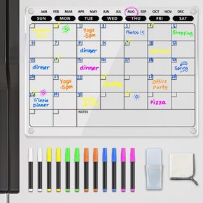 تقويم لوح مسح جاف مغناطيسي من الأكريليك للثلاجة، سبورة بيضاء مخططة شهرية شفافة للثلاجة مع 12 علامة ومنشفة نابضة بالحياة، 16 بوصة × 12 بوصة
KWD 6.500
تقويم لوح مسح جاف مغناطيسي من الأكريليك للثلاجة، سبورة بيضاء مخططة شهرية شفافة للثلاجة مع 12 علامة ومنشفة نابضة بالحياة، 16 بوصة × 12 بوصة
KWD 6.500
 Excelmark 2 "× 8" لوحة اسم محفورة مخصصة مع زوايا مربعة
KWD 4
Excelmark 2 "× 8" لوحة اسم محفورة مخصصة مع زوايا مربعة
KWD 4
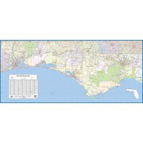 خريطة جدار مغلفة في فلوريدا (48 بوصة على ارتفاع 22 بوصة)
KWD 62
خريطة جدار مغلفة في فلوريدا (48 بوصة على ارتفاع 22 بوصة)
KWD 62
 -11%
موارد التعلم MathLink مكعبات - مجموعة من 100 مكعب ، تتراوح أعمارهم بين 5+ رياض الأطفال ، أنشطة STEM ، معالجات الرياضيات ، لوازم المدرسة المنزلية ، مستلزمات المعلمين
KWD 4
-11%
موارد التعلم MathLink مكعبات - مجموعة من 100 مكعب ، تتراوح أعمارهم بين 5+ رياض الأطفال ، أنشطة STEM ، معالجات الرياضيات ، لوازم المدرسة المنزلية ، مستلزمات المعلمين
KWD 4


