- Shopping, made easy.
- /
- Get the app!

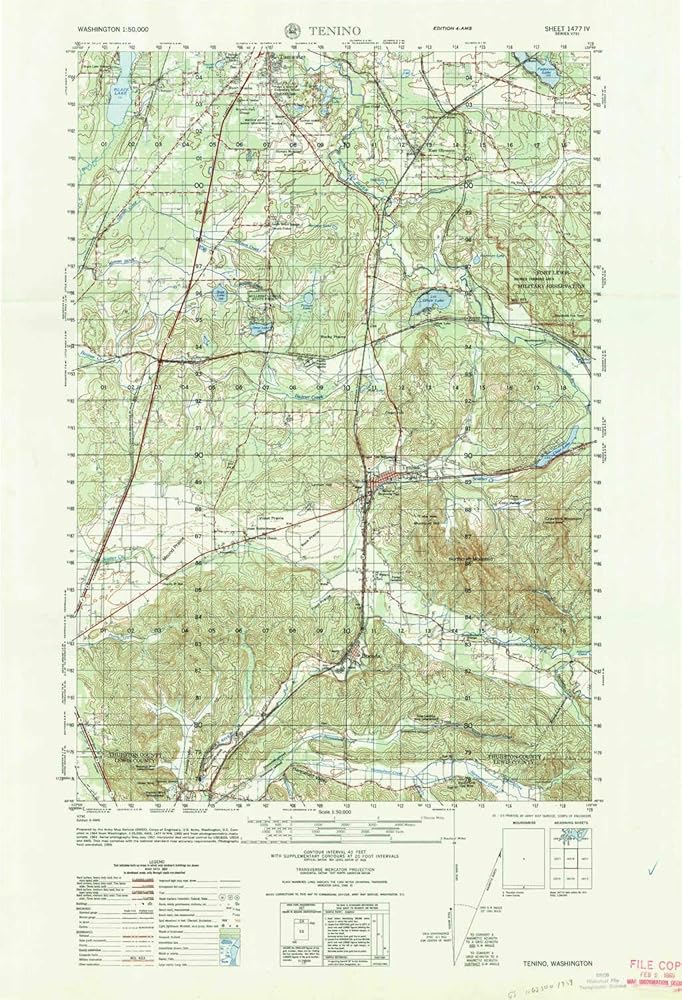
USGS topographic map of Tenino, Washington, dated 1964, updated 1965.
Includes geographic coordinates (latitude and longitude), lines of elevation, bodies of water, roads, and more. This topo quad is suitable for recreational, outdoor uses, office applications, or wall map framing.
Printed on-demand by YellowMaps on the print material of your choice.
Shipping rolled from Minneapolis, MN, United States.
Product Number: USGS-5679114
Map Size: 29.2 inches high x 19.9 inches wide
Map Scale: 1:50000
Map Type: POD USGS Topographic Map
Map Series: HTMC
Map Version: Historical
Cell ID: 63447
Scan ID: 244233
Imprint Year: 1965
Woodland Tint: Yes
Aerial Photo Year: 1957
Field Check Year: 1959
Datum: NAD27
Map Projection: Transverse Mercator
Map published by United States Army Corps of Engineers
Map published by United States Army
Map Language: English
Scanner Resolution: 600 dpi
Map Cell Name: Tenino
Grid size: 15 X 15 Minute
Date on map: 1964
Geographical region: Washington, United States
Northern map edge Latitude: 47°
Southern map edge Latitude: 46.75°
Western map edge Longitude: -123°
Eastern map edge Longitude: -122.75°
Surrounding map sheets (copy & paste the Product No. in the search bar):
North: USGS-5408808,USGS-5408806,USGS-5410396,USGS-5408804,USGS-5410392
East: USGS-5410938,USGS-5408910,USGS-5408906,USGS-5408908,USGS-5410936
South: USGS-5403274,USGS-5403268,USGS-5409630,USGS-5403270,USGS-5409628
West: USGS-5410590,USGS-5410592,USGS-5409834,USGS-5407684,USGS-5410588
 YellowMaps Clanton East AL topo map, 1:24000 Scale, 7.5 X 7.5 Minute, Historical, 1972, Updated 1984, 26.7 x 21.9 in
KWD 12.500
YellowMaps Clanton East AL topo map, 1:24000 Scale, 7.5 X 7.5 Minute, Historical, 1972, Updated 1984, 26.7 x 21.9 in
KWD 12.500
 Outdoor Trail Maps LLC Eagles Nest Wilderness - Colorado Topographic Hiking Map (2018)
KWD 4
Outdoor Trail Maps LLC Eagles Nest Wilderness - Colorado Topographic Hiking Map (2018)
KWD 4
 Outdoor Trail Maps Maroon Bells-Snowmass Wilderness - Colorado Topographic Hiking Map (2022)
KWD 4
Outdoor Trail Maps Maroon Bells-Snowmass Wilderness - Colorado Topographic Hiking Map (2022)
KWD 4
 Mount Evans Wilderness - Colorado Topographic Hiking Map (2018)
KWD 4
Mount Evans Wilderness - Colorado Topographic Hiking Map (2018)
KWD 4