- Shopping, made easy.
- /
- Get the app!

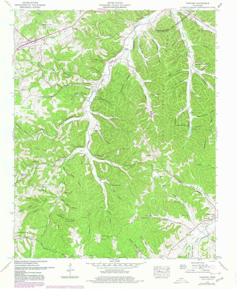
USGS topographic map of Fairview, Tennessee, dated 1951, updated 1980.
Includes geographic coordinates (latitude and longitude), lines of elevation, bodies of water, roads, and more. This topo quad is suitable for recreational, outdoor uses, office applications, or wall map framing.
Printed on-demand by YellowMaps on the print material of your choice.
Shipping rolled from Minneapolis, MN, United States.
Product Number: USGS-5334262
Map Size: 27.4 inches high x 22 inches wide
Map Scale: 1:24000
Map Type: POD USGS Topographic Map
Map Series: HTMC
Map Version: Historical
Cell ID: 14877
Scan ID: 147495
Imprint Year: 1980
Woodland Tint: Yes
Visual Version Number: 1
Photo Revision Year: 1980
Aerial Photo Year: 1977
Edit Year: 1980
Datum: NAD27
Map Projection: Polyconic
Map published by Tennessee Valley Authority
Map Language: English
Scanner Resolution: 600 dpi
Map Cell Name: Fairview
Grid size: 7.5 X 7.5 Minute
Date on map: 1951
Geographical region: Tennessee, United States
Northern map edge Latitude: 36°
Southern map edge Latitude: 35.875°
Western map edge Longitude: -87.125°
Eastern map edge Longitude: -87°
Surrounding map sheets (copy & paste the Product No. in the search bar):
North: USGS-5335406,USGS-5335408,USGS-5335402,USGS-5335404
East: USGS-5335606,USGS-5335614,USGS-5335608,USGS-5335610,USGS-5335616
South: USGS-5677612,USGS-5337998,USGS-5338000,USGS-5337996,USGS-5337994
West: USGS-5333674,USGS-5333680,USGS-5333676,USGS-5333678
 YellowMaps Clanton East AL topo map, 1:24000 Scale, 7.5 X 7.5 Minute, Historical, 1972, Updated 1984, 26.7 x 21.9 in
KWD 12.500
YellowMaps Clanton East AL topo map, 1:24000 Scale, 7.5 X 7.5 Minute, Historical, 1972, Updated 1984, 26.7 x 21.9 in
KWD 12.500
 Outdoor Trail Maps LLC Lost Creek Wilderness - Colorado Topographic Hiking Map (2022)
KWD 4
Outdoor Trail Maps LLC Lost Creek Wilderness - Colorado Topographic Hiking Map (2022)
KWD 4
 YellowMaps Dyas AL topo map, 1:50000 Scale, 15 X 15 Minute, Historical, 2003, 29.1 x 22.1 in
KWD 16.500
YellowMaps Dyas AL topo map, 1:50000 Scale, 15 X 15 Minute, Historical, 2003, 29.1 x 22.1 in
KWD 16.500
 Gila Wilderness WEST - New Mexico Hiking (2023)
KWD 4.500
Gila Wilderness WEST - New Mexico Hiking (2023)
KWD 4.500