- Shopping, made easy.
- /
- Get the app!
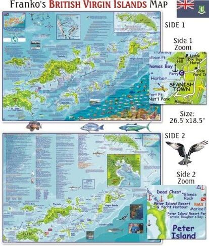
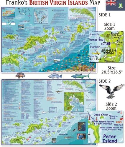
Loaded with information for everything there is to see and do. The colorful maps have shaded relief on land masses and hues of blue to denote water depths. Side One highlights Jost Van Dyke, Tortola and Virgin Gorda. Inset map of Anegada and detail illustration of the RMS Rhone wreck. There are colorful illustrations of BVI coral reef creatures. Side Two covers the entire BVI island group. Inset map of Road Town, Tortola. Dive and snorkel sites are located, named, and described with detailed text. Guide text includes dive operators, charter boats, island facts and more. This is a map and a guidebook rolled into one. Enough info to help you plan your trip and a handy reference to carry and use while on island. 18"x 26", folded to 4.5" x 9" and printed on waterproof, rip-resistant synthetic stock.
 YellowMaps Clanton East AL topo map, 1:24000 Scale, 7.5 X 7.5 Minute, Historical, 1972, Updated 1984, 26.7 x 21.9 in
KWD 12.500
YellowMaps Clanton East AL topo map, 1:24000 Scale, 7.5 X 7.5 Minute, Historical, 1972, Updated 1984, 26.7 x 21.9 in
KWD 12.500
 Lizard Head - Mount Sneffels Wilderness - Colorado Topographic Hiking Map (2018)
KWD 4
Lizard Head - Mount Sneffels Wilderness - Colorado Topographic Hiking Map (2018)
KWD 4
 Beartooth Publishing Wind River Range South, Wyoming Topographic Shaded Relief Outdoor Recreation Map
KWD 8
Beartooth Publishing Wind River Range South, Wyoming Topographic Shaded Relief Outdoor Recreation Map
KWD 8
 Outdoor Trail Maps LLC Hunter-Fryingpan/Mount Massive Wilderness - Colorado Topographic Hiking Map (2018)
KWD 4
Outdoor Trail Maps LLC Hunter-Fryingpan/Mount Massive Wilderness - Colorado Topographic Hiking Map (2018)
KWD 4