- التسوق ، اصبح سهلا.
- /
- احصل على التطبيق!
20.75 x 18.5 inches. Laminated. Flat map, tubed for shipping.
This colorful, easy-to-read state map of Connecticut identifies all major thoroughfares, secondary roads, freeway interchanges, rest areas, distance markers, landmarks, recreational areas, and more. Shaded relief on the state map provides a three-dimensional sense of Connecticut's topography. Detailed city inset maps of Hartford, New Haven-Bridgeport, New London, Stamford, and Waterbury are based on the latest street information from our cartographic experts. County and city indices make it simple to locate even the smallest town.
Created by Globe Turner, one of the leading producers of map products in the USA.
 خريطة أمريكا الشمالية HISTORIX 2021 - خريطة جدار أمريكا الشمالية مقاس 18 × 24 بوصة - خريطة أمريكا الشمالية - خريطة حائط أمريكا الشمالية - ملصق خريطة أمريكا الشمالية
KWD 16.500
خريطة أمريكا الشمالية HISTORIX 2021 - خريطة جدار أمريكا الشمالية مقاس 18 × 24 بوصة - خريطة أمريكا الشمالية - خريطة حائط أمريكا الشمالية - ملصق خريطة أمريكا الشمالية
KWD 16.500
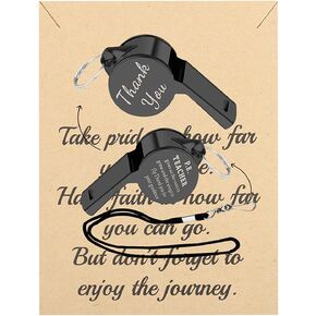 FUSTMW PE صافرة المعلم الهدايا P.E. هدايا تقدير المعلم، هدايا مدرس التربية البدنية، هدايا مدرس الصالة الرياضية، هدايا شكر لك
KWD 4.500
FUSTMW PE صافرة المعلم الهدايا P.E. هدايا تقدير المعلم، هدايا مدرس التربية البدنية، هدايا مدرس الصالة الرياضية، هدايا شكر لك
KWD 4.500
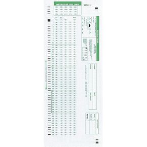 نماذج اختبار متوافقة مع TEST-100E 882 E (عبوة من 500 ورقة)
KWD 4
نماذج اختبار متوافقة مع TEST-100E 882 E (عبوة من 500 ورقة)
KWD 4
 كتاب الأطفال المزدحم من هاي كيدو، أحدث ألعاب التوحد لعام 2022 للأطفال، غلاف نشاط تعلم ما قبل المدرسة، كتاب تعليمي للتوحد والاحتياجات الخاصة، كتاب رسم للتعلم المنزلي والمدرسة
KWD 8
كتاب الأطفال المزدحم من هاي كيدو، أحدث ألعاب التوحد لعام 2022 للأطفال، غلاف نشاط تعلم ما قبل المدرسة، كتاب تعليمي للتوحد والاحتياجات الخاصة، كتاب رسم للتعلم المنزلي والمدرسة
KWD 8

