- التسوق ، اصبح سهلا.
- /
- احصل على التطبيق!
This fully indexed and highly detailed map is ideally sized (42" x 39") making it perfectly readable, yet small enough to be incorporated into most any existing wall space. Includes all state, US and Interstate highways, cities & towns, airports, elevations, rivers, lakes, parks and county names and boundaries. Also included are inset maps of telephone area codes and statewide elevation contours and a mileage chart.
 خزانة تخزين الفنون/الصياغة في الفصول الدراسية المتنوعة، مقاس 32 بوصة عرض × 22 بوصة عمق × 84 بوصة ارتفاع، 25 فتحة 20 بوصة × 26 بوصة، خشب القيقب الصلب، أبواب قفل مزدوجة، صنع في الولايات المتحدة الأمريكية
KWD 626.500
خزانة تخزين الفنون/الصياغة في الفصول الدراسية المتنوعة، مقاس 32 بوصة عرض × 22 بوصة عمق × 84 بوصة ارتفاع، 25 فتحة 20 بوصة × 26 بوصة، خشب القيقب الصلب، أبواب قفل مزدوجة، صنع في الولايات المتحدة الأمريكية
KWD 626.500
 مخطط جيب للتخزين بلون اسود (32.5 انش × 36.5 انش)
KWD 12
مخطط جيب للتخزين بلون اسود (32.5 انش × 36.5 انش)
KWD 12
 8 قطع شرائط قراءة موجهة، شرائط تسليط الضوء الملونة، تراكبات قراءة الإشارات المرجعية، أجهزة تتبع خط القراءة للأطفال الذين يعانون من عسر القراءة، شرائط القراءة، أدوات قراءة الطلاب
KWD 2.500
8 قطع شرائط قراءة موجهة، شرائط تسليط الضوء الملونة، تراكبات قراءة الإشارات المرجعية، أجهزة تتبع خط القراءة للأطفال الذين يعانون من عسر القراءة، شرائط القراءة، أدوات قراءة الطلاب
KWD 2.500
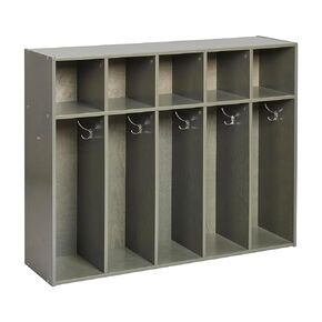 ECR4Kids تبسيط خزانة معطف الأطفال الصغار المكونة من 5 أقسام، وأثاث الفصول الدراسية، باللون الأبيض
KWD 84
ECR4Kids تبسيط خزانة معطف الأطفال الصغار المكونة من 5 أقسام، وأثاث الفصول الدراسية، باللون الأبيض
KWD 84


