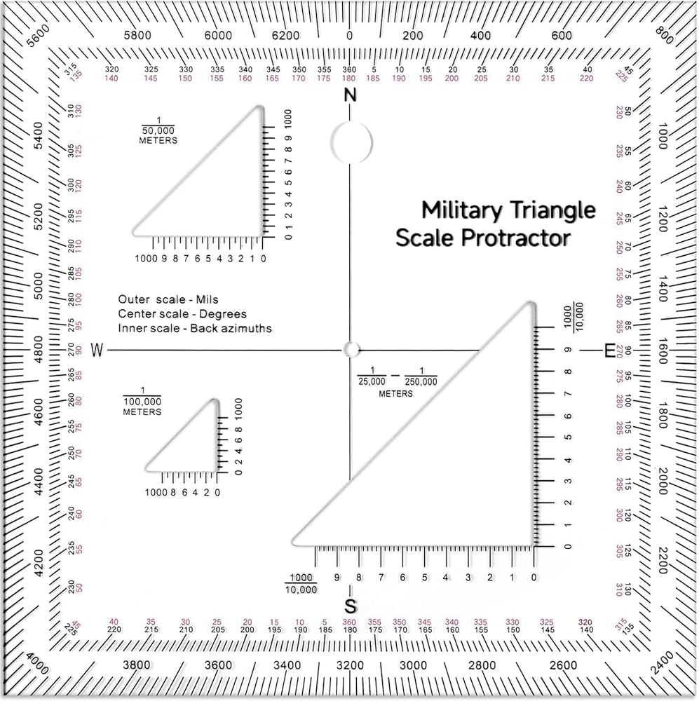
Ultra-Clear & Durable – Made from high-strength transparent acrylic with permanent black markings that resist fading and wear. The 5x5 inch size provides a full view of underlying map details, featuring precise coordinate grid lines from 0 to 10,000 for exact plotting (e.g., 5400, 5200) and cardinal directions (N/E/S/W) for quick orientation.
Multi-Scale Accuracy – Compatible with all standard military map scales: 1:10,000, 1:25,000, 1:50,000, 1:100,000, and 1:250,000. Ideal for use with UTM, MGRS, and USNG metric coordinate systems, ensuring seamless distance and coordinate measurement across different maps.
Professional Dual Angle Scales – Features an inner degree scale (0°–360°) for standard compass navigation and an outer mils scale for tactical operations. Includes reverse azimuths for instant back-bearings, saving critical time during land navigation and artillery training.
Official Army GT A-5-2-12 Equivalent – Meets the specifications of the Graphic Training Aid 5-2-12, the standard protractor used in military land navigation courses. A must-have for ROTC, cadets, search-and-rescue teams, and serious hikers.
Practical Gift – Perfect as a thoughtful gift for military personnel, surveyors, outdoor enthusiasts, and cartography students, enhancing precision in force measurement, training benchmarks, and everyday map reading.
وصف
Military Map Protractor Coordinate Scale Map,Military Style UTM/MGRS Coordinate Scale,Reading and Land Navigation Topographical Map Scale, Protractor and Grid Coordinate Reader
Specifications:
Material: acrylic
Color: clear
Size: about 5 x 5 inches
 -11%
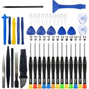
مجموعة أدوات إصلاح أدوات فتح الأجهزة الإلكترونية الاحترافية المكونة من 42 قطعة مزودة بأدوات نايلون من الفولاذ والألياف الكربونية، وملاقط مضادة للكهرباء الساكنة و13 مفكًا للهواتف المحمولة المفتوحة وأجهزة الكمبيوتر المحمولة والأجهزة اللوحية
KWD 4
-11%
مجموعة أدوات إصلاح أدوات فتح الأجهزة الإلكترونية الاحترافية المكونة من 42 قطعة مزودة بأدوات نايلون من الفولاذ والألياف الكربونية، وملاقط مضادة للكهرباء الساكنة و13 مفكًا للهواتف المحمولة المفتوحة وأجهزة الكمبيوتر المحمولة والأجهزة اللوحية
KWD 4
 طقم إصلاح أدوات فتح الأجهزة الإلكترونية الاحترافية مكون من 42 قطعة مع أدوات تصليح من النايلون من الفولاذ والألياف الكربونية، وملاقط مضادة للكهرباء الساكنة و13 مفكًا للهواتف المحمولة المفتوحة وأجهزة الكمبيوتر المحمولة والأجهزة اللوحية (أسود)
KWD 4.500
طقم إصلاح أدوات فتح الأجهزة الإلكترونية الاحترافية مكون من 42 قطعة مع أدوات تصليح من النايلون من الفولاذ والألياف الكربونية، وملاقط مضادة للكهرباء الساكنة و13 مفكًا للهواتف المحمولة المفتوحة وأجهزة الكمبيوتر المحمولة والأجهزة اللوحية (أسود)
KWD 4.500
 Raymay Fujii JC705B Compass Pen Pass Type ، Black
KWD 7.500
Raymay Fujii JC705B Compass Pen Pass Type ، Black
KWD 7.500
 -13%
أفضل اللحامات 900-CHEM-SHARP-JAR-المبراة الكيميائية ، جرة بديلة
KWD 10
-13%
أفضل اللحامات 900-CHEM-SHARP-JAR-المبراة الكيميائية ، جرة بديلة
KWD 10